About Atlas Nautical Charts
Mapitech launches Atlas, a worldwide digital cartography that combines vector data with the best official up-to-date paper charts ie marinas, depth contours, wrecks, fishing spots, boat ramps, POI and many other features....
Mapitech launches Atlas, a worldwide digital cartography that combines vector data with the best official up-to-date paper charts ie marinas, depth contours, wrecks, fishing spots, boat ramps, POI and many other features.
The beauty of paper charts enriched with digital cartography.
Chart details and performance of a professional GPS chart plotter in the palm of your hand.
Appealing appearance, easy to use, useful to have on board with you.
The app works without mobile coverage (offline).
The interactive menu is intuitive and allows you to purchase maps for offline use at an amazing price.
Free Features and Functions:
•Powerful search
•Multiple overlays for different use (fishing, sailing or cruising)
•KML data shareable
•Very detailed and updated charts
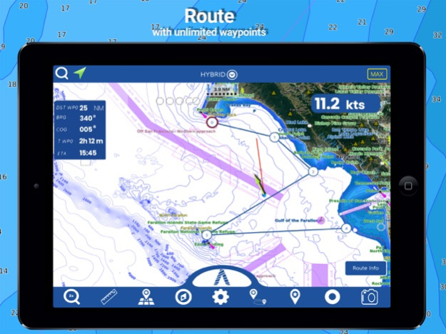
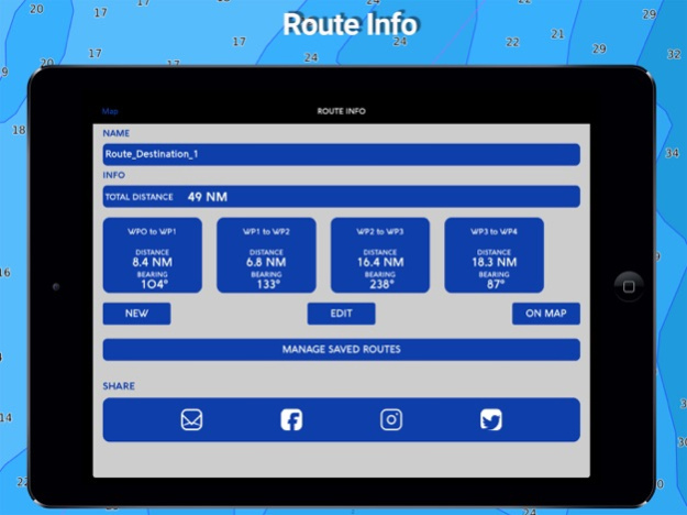
•Unlimited Waypoints
•Markers & Favorites
•Magnifying Lens for all info
•Multiple tracks: Record your track, instant speed time, COG - course over ground
•Route planning, Waypoints - Insert the destination and see in real time your speed, distance and bearing
•Geo-tagged photo management, Share via email, visible on Google
•Distance Measurement Tool to easily calculate the distance
•Compass
•GPS window with very detailed info
•User friendly on latest IOS
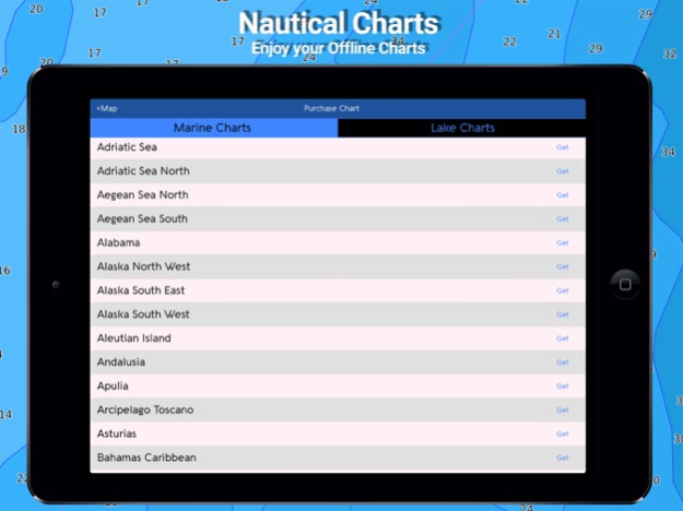
- MARINE MAPS
Detailed Electronic Nautical Charts (ENC) which include Coastline, Anchoring areas, Fishing areas, Restricted areas, Obstructions, Rocks, Buoys, Beacons, Lights, Depth contours, Spot Soundings and more.
- LAKE MAPS
High quality lake maps with detailed information and important features: Depth Contours, Boat Ramps, Fishing spots etc. Maps also include Trails, Roads and Railways information.
PURCHASING INCLUDES:
•Offline Chart: Choose your favorite area from our catalogue and get a detailed chart of your area
•Subscription for 1 year: Get a trial of all our charts and features and subscribe for one year
•Lifetime Purchase: Get all our charts and features for Lifetime
MORE INFO:
Terms of Use: https://mapitech.com/disclaimer/
Privacy Policy: https://mapitech.com/privacy-policy/
Feb 24, 2023
Version 1.5.23
Charts added:
Cape Fear
Delaware Bay
Florida North West
Los Angeles
Los Angeles to Sandiego
Lower Chesapeake
Matagorda Bay
Mississippi River Delta
Nantucket Sound
New Orleans
New Haven Sandy Hook
North Atlantic Canyon East
Outer Delmarva Peninsula
Pamlico Sound
Previous Versions
Here you can find the changelog of Atlas Nautical Charts since it was posted on our website on 2021-12-14 05:42:17.
The latest version is 1.5.23 and it was updated on 2024-04-22 18:40:53. See below the changes in each version.
Atlas Nautical Charts version 1.5.23
Updated At: 2023-02-24
Changes: Feb 24, 2023
Version 1.5.23
Charts added:
Cape Fear
Delaware Bay
Florida North West
Los Angeles
Los Angeles to Sandiego
Lower Chesapeake
Matagorda Bay
Mississippi River Delta
Nantucket Sound
New Orleans
New Haven Sandy Hook
North Atlantic Canyon East
Outer Delmarva Peninsula
Pamlico Sound
Atlas Nautical Charts version 1.5.21
Updated At: 2022-08-06
Changes: Aug 6, 2022 Version 1.5.21
Charts added:
Clair Engle and Trinity Lake
Atoka Reservoir
Hugo Lake Oklahoma
Lake Stanley Draper
Atlas Nautical Charts version 1.5.18
Updated At: 2022-02-02
Changes: Feb 2, 2022
Version 1.5.18
Charts added:
NamuHarbor Hiekish Narrows
CaamanoSound Laredo Sound
Hawkesbury Channel
Browning Entrance
Chatham Sound
Portland Canal
Moresby Island
SW Nova Scotia
SouthWest Cuba
NorthWest Cuba
Atlas Nautical Charts version 1.5.17
Updated At: 2021-11-23
Changes: Nov 23, 2021 Version 1.5.17
Charts added:
Wister Reservoir
Glafsfjorden
Vancouver to PittLake
Coronado Ferry Landing Pier
Estepona Sines
Rio de la Plata
Gulfislands
StraitOf Georgia
Desolation Sound
Port Neville Blunden Harbor
Queen Charlotte Strait
Northwest Vancouver Islands
Nootka Sound
Clayoquot Barkley Sounds
King Island
Vancouver Approaches (BC)
Gulf Islands
Disclaimer
Official App Store Link
We do not host Atlas Nautical Charts on our servers. We did not scan it for viruses, adware, spyware or other type of malware. This app is hosted by Apple and passed their terms and conditions to be listed there. We recommend caution when installing it.
The App Store link for Atlas Nautical Charts is provided to you by apps112.com without any warranties, representations or guarantees of any kind, so access it at your own risk.
If you have questions regarding this particular app contact the publisher directly. For questions about the functionalities of apps112.com contact us.